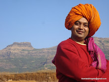
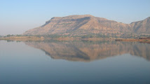
The southern part of Konkan is adorned by natural beauty. The city of Roha is situated on the banks of Kundalika River. Avchitgad is situated in the mountain ranges around Roha. This region is beautiful, and the fort is one of the rich forts of Maharashtra. Dense woods along the mountain have made it bit difficult to ascend the top.
Fact File
Location: Roha, Raigad
Distance from major cities:
Mumbai - 185 km
Pune - 130 km
Villages at Foothills: Pengalsai, Medha, Padam
Altitude: 977' (297 m)
Latitude: 18°28'32"N
Longitude: 73°7'5"E
Best time to visit: Throughout the year. Best during the monsoon {mosmap lat='18.475620'lon='73.118230'}
top
Attractions The main entrance to the fort is still in better condition. The bastion on the way from Medhe was much better for keeping a watch on the surrounding region. As we proceed further from the main entrance, we come across the remnants of old constructions on a neighboring hillock. Near the second entrance there is a lake. The water is potable here. Near to it is a statue of Lord Khandoba. The fort is not too wide, but stretches in length. It takes about two hours to
see the fort. The forest around the fort is dense and the fauna comprises wild hogs, leopards, foxes, monkeys, etc. It is a best monsoon trek. rom the top of Avchitgad we can have a glimpse of Telbaila, Sudhagad, Sarasgad, Dhangad, Raigad, Korigad and Savashna Ghat.
topReaching There
- By Air -
Mumbai is the nearest airport well connected by flights from all over.
- By Rail -
Roha on the Kokan railway route is the nearest rail head.
- By Road -
Pengalsai, Medha and Padam are the villages at foot hills and can be accessed by regular bus service from Roha.
topTrek Routes
- Pengalsai Route (Grade : Easy) -
Pengalsai is situated at about 5 km from Roha. It is the base village. From here it takes one hour to reach the top.
- Medha Route (Grade : Easy) -
The village of Medha is 7.5 km before Roha on Mumbai-Roha highway. The way to the fort goes along the temple of Lord Vitthal. We have to ascend through thick woods and reach the front bastion after one hour.
- Padam Route (Grade : Easy) -
There is an old factory in the village of Padam. Beyond this factory is the way to the fort, which takes us to the southern entrance within two hours.
top Accommodation
No shelter available on fort. Hence advisible to carry tents for camping or find accommodation at Roha.
Sunday, July 13, 2008
Avchitgad
Asheri
Of all the small forts scattered around the Palghar region, Asheri can be termed
as the Elder Brother" due to its massiveness and height. As it covers a huge area the fort looks impressively strong.
Fact File
Location: Palghar, Thane
Distance from major cities:
Mumbai - 95 km
Pune - 255 km
Villages at Foothills: Khodkona
Altitude:1680' (512 m)
Latitude: Longitude:
Best time to visit: Throughout the year. Best during the monsoon {mosmap lat='19.612847'lon='73.178301'}
topHistory History mentions that Bhojraj, a descendant of the Shilahar Dynasty built this fort. Hence it can be assumed that this fort is at least 800 years old. The Portuguese rebuilt this fort after they captured it during their rule. In 1737, Peshwa won this fort during his campaign of the Konkan and in 1818 this fort came under the British rule.
topAttractions
On the plains and on the right of the path one can see quite many remnants of settlements. One can also see quite many foundations with gutters cut in them. These could be to collect the rainwater during the rainy season or to lead away the overflow. The cave on the top is of medium size and having a large cave opening. But it has been carved into the rocks in such a way that the stray wind or the cold does not enter in. The back portion of the cave is very uneven.
However, there are platforms made both outside and inside for the guards to take rest. The two hibiscus bushes outside the cave entrance point to the fact that rituals might have been conducted regularly by the villagers somewhere in the past. On left side of the top portion of the cave, there is a built in square water tank. There is a half buried cannon in this tank. There are two more half completed tanks here. From the top plateau, one can see the fort of Kohoj to the South West. One can also see the natural human form on the fort with the help of binoculars. Going ahead on the path one can see a huge depression the rock face and a bastion.
topReaching There
- By Air -
Mumbai is the nearest airport well connected by flights from all over.
- By Rail -
Palghar is the nearest rail head.
- By Road -
Regular ST buses ply from Palghar to Khodkona which is the base village.
topTrek Routes
Khodkona Route (Grade : Medium) - 2 hrs
There is only one route going to the top of the fort. One has to get down at Khodkona village bus stop. This village is reachable either by the S.T. from Palghar to Kasa or by private vehicles plying this highway. This village is situated around 10-11 kms ahead of Mastan Naka". The actual village is situated a bit inside from the main road. There is a bullock cart route to the left of the highway, which leads to the village. On the highway, if one stands with his back to
Palghar, one can see Adsul to the right and the vast expanse of Asher to the left. The bullock cart route enters the village via a small bridge. Here, the small beautiful temple of Vagdev can be seen. On entering the village we see the vast expanse of fields, cultivation of mango trees and houses peeking from the greenery, which drives away the tiredness of the journey . After quenching the thirst and filling bottles with the cool well water, one should proceed ahead towards the fort, on the route shown by the villagers. As the route goes through dense jungle, one does not feel the heat even in the summer. It takes approximately 1 to 1 hours to reach the pass. The route up to the pass is easy but continuously climbing. There is a temple of Vagdev a bit ahead of this pass on a higher level. One should turn to right and proceed towards the top of the fort. We reach the base of the entrance as we go around a huge rock face in the route. Here one can find a small sculpture of Ganesh on the rock face. The entrance has been destroyed by explosives. Here, care must be taken while climbing up. As the climb is quite zigzag and steep, it is advisable to take help from someone Expert in climbing. If possible, climb without any sacks on your back. After exhausting enthusiasm to climb, we reach a flight of steps cut into the rock face to the right. There are quite many water tanks on the way, but are not potable. From this
water tank, we can reach the middle of the fort making way through the shoulder length bushes growing here. To the left, below the route are 5 water tanks excavated into the rocky ground. Of these one tank has potable water. Walking ahead, after 5 minutes, another path bifurcates to the left. Going down this route, we come across three more water tanks. The water in these tanks is very clear, sweet and thirst quenching. There is also a cave on the rock face nearby on right hand side.
topAccommodation
With proper camping gear one can lodge at the temple and the plinth built outside. 10-15 people can camp here.
Arnala
The fort of Arnala overlooks the confluence of River Vaitarna and the Arabian Sea. Adroitly bulit on the Arnala island; the fort walls offers breathtaking views of the sea.
Fact File
Location: North West of Mumbai, on Arnala Island
Distance from major cities:
Mumbai - 80 km
Pune -240 km
Villages at Foothills: Arnala, Virar
Altitude: Sea Level
Latitude: 19°27'57"N
Longitude: 72°43'56"E
Best time to visit: September to April {mosmap lat='19.466097'lon='72.732464'}
topHistory Sultan Mahmood Begda of Gujarat built the sea fort of Arnala in 1516. In 1530 Portuguese won this fort and built new structures on it. Portuguese ruled over the fort for more than 200 years. Later the Marathas conquered it. Bajirao-I reconstructed fort like the Portuguese. In 1817, like all the other forts, British captured this fort too.
topAttractions The fort is approximately rectangular in shape and is being protected by continuous and strong ramparts having a height of about 10 meters. The bastions are in good condition even today. There are three entrances to the fort out of which the main entrance is on the north side. Two lofty bastions guard the mighty entrance. Sharabha shilpa is carved at the entrance. A lithograph at the door indicates that Bajirao Peshwa reconstructed the fort. The fort houses temples of Tryambakeshwar, and Bhavani Mata. In front of Tryambakeshwar Mahadev, temple is a skillfully crafted octagonal cistern. Wells of portable water are in the fort. Near the entrance of the fort, that is the northern phase of the island is a temple of Kalikamata,
From the fort walls a bastion is seen far off from the fortification. It was supposedly used as a watch tower. It offers a magnificent view of the surroundings.
topReaching there
- By Air -
The nearest Airport is Mumbai ( km away). Mumbai is well connected by international and domestic flights from all over.
- By Rail -
Virar is the nearest railway station (barely 10 km away) from Arnala
- By Road -
Arnala fort is just 10 km off the Virar railway station on the Western Railway route. Regular buses and six-seater
autorickshaws ply between Virar and Arnala shore. The village on the Arnala island can be reached only after a boat rite. The fishermen boats are available between 6 am and 12:30 pm in the morning and between 4 pm and 7 pm in the evening. It is barely a 10 minute ride to the island.
topBus Timings
The ST bus plies between Virar and Arnala every half an hour.
topAccommodation
No accommodation in the fort. One will have to find accommodation in various hotels available at Virar
Alang
Alang, Madan and Kulang, the forts situated in Kalasubai range, are the most difficult forts in Nasik District. Dense forest and less population have made these treks difficult. These three forts are little neglected due to very heavy rain and difficult as well as confusing ways to go.
Fact File
Location: North west of Nasik
Villages at Foothills: Ambewadi
Altitude:4852' (1479 m)
Latitude: 19°34'50"N
Longitude: 73°39'38"E
Best time to visit: Throughout the year. Best during winter {mosmap lat='19.578553'lon='73.662815'zoom=7}
topAttractions Top of the fort is huge plateau. There are two caves on the fort for staying and 11 water cisterns. Remnants of buildings are spread over the fort. A small temple is also seen. From the fort we can locate Kalasubai, Aundh Fort, Patta, Bitangad situated at east zone. At north side Harihar, Trymbakgad, Anjaneri are seen. To the south we can locate Harishchandragad, Aajobagad, Khutta (pinnacle), Ratangad, Katrabai and surroundings. 4 hours are
enough to see the fort.
topReaching There
- By Air -
Nasik is the nearest Airport. But it has only one flight from Mumbai. Thus it is suggested to fly to Mumbai or Pune and drive down.
- By Rail -
Nasik Road is the nearest rail head.
- By Road -
From Nasik one needs to reach Satana or Taharabad. Only 2 buses ply to the foothills of the for, and hence one needs to plan the trek well.
topTrek Routes
- Ambewadi village Route (Grade : Tough) - 6 - 8 hrs To reach Alang, one should go to Kasara or Igatpuri and then
Ambevadi by the Igatpuri/Kasara-Ghoti-Pimpalnermor route. Bus facility from Ghoti to mbevadi is also available.
Ambevadi is 32 km away from Ghoti. A bus is available at 6 a.m. from Ghoti to Ambevadi. We can easily see Alang, Madan and Kulang from here. From Ambevadi, a way goes to the ridge between Alang and Madan. However this way is quite hectic. Approximately 3 hours are required to reach near the ridge. From the ridge, the fort seen on left is Alang and the one on the right is Madan.
From here two ways go towards Alang.
a) One way descends from the ridge. Within 1 hour we reach at the plateau. Keep Alang at left hand and after 1-hour walk, we reach a cavern. From here we can move further by rock climbing. Then we reach at a flat patch. Keep left and proceed towards the pinnacle. After 10-15 minutes we come at a cave in the fort.
b) Proceed from the ridge and after easy rock climbing we come near few steps. After ascending these steps we have to climb a broken pinnacle of 80-90 ft. Only trained climbers can go by this way. By this way we reach at the fort after 6 hours.
- Ghatghar via Ghoti-Bhandardara - 2 hrs
Another way towards fort is from Ghatghar. Go at Ghatghar via Ghoti-Bhandardara. From here, in 2 hours, one can cometo the third cavern.
- Via Bhandardara from Udadvade - 3 hrs
Other way towards fort is via Bhandardara from Udadvade gaon. It takes us at the plateau and then connects to Ghatghar route.
topAccommodation
Two caves on the fort can accommodate 30-40 people.
Ajoba
Ajoba is a prominent peak near Ratangad. One can get a beautiful view of the Katrabai cliffs from the top of Ajoba.
Fact File
Location: Shahapur, Thane
Distance from major cities:
Mumbai - 130 km
Pune - 160 km
Villages at Foothills: Dehene, Dolkhamb
Altitude: 4511' (1374 m)
Latitude: 19°27'52"N
Longitude: 73°40'58"E
Best time to visit: September to January {mosmap lat='19.464569'lon='73.682814'zoom=5}
topAttractions Near the Ashram, there is a small hut where we can stay. A small water stream provides us with pure water. The way beyond Ashram leads to a rivulet, crossing which we can reach the cave of LUV-KUSH. To reach this spot we have to ascend the way of waterfall for one and half hour. Above this cave there is a precipice called 'Cradle of Sitamai'. In the cave there are the carved Padukas" or the footprints of Luv and Kush. This precipice is a real challenge
for trekkers. The ashram is a sacred place and people from all over Maharashtra come here. There are some carved stones near the ashram, on which some carved idols depict some story.
From this place, we can visit Ratangad. For a 5-day cross-country trek, the trio of Ratangad - Harishchandragad-Ajoba can be planned.
topReaching There
- By Air -
Mumbai is the nearest airport well connected by flights from all over.
- By Rail -
Asangaon is the nearest rail head.
- By Road -
Regular ST buses ply from Asangaon to Dolkhamb.
topTrek Routes
- Asangaon Route (Grade : Easy) - 1 hr
One should board the train to Kasara and alight at Asangaon station. From Asangaon, board the S.T bus to Shahapur and from there we can reach the village of Dehne by bus or jeep. From Dehne, a sole pathway leads to a small plateau, from which 3 ways branch:
a) One way is treaded by bullock carts and goes to the plateau where the ashram is situated.
b) The second goes through`Katrabai,s`valley and joins`Kumshet, village
c) Third way goes through the forest.
- Dolkhamb Route (Grade : Easy) - 1 hr
Kalyan-Murbad-Malshej-Dolkhamb is another route
- Kumshet Route (Grade : Easy) - 1.5 hrs
To reach the top of the fort one should follow the route of Kasara-Ghoti-Rajur-Kumshet.
topBus Timings
Shahapur - Dolkhamb : 0700, 0830, 1130, 1330, 1630,1845,2000
Dolkhamb - Shahapur : 0600, 0930, 1400, 1730, 1915
topAccommodationNear to the ashram, there is a hut where about 20 people can stay. Care should be taken from snakes and scorpions. Generally people prefer this place as one-day trek, especially in rainy season. A beautiful waterfall is formed in monsoon.
Ajinkyatara
Fact File
Location: South west of Pune
Distance from major cities:
Mumbai - 277 km
Pune - 117 km
Satara - 7 km
Villages at Foothills: Satara
Altitude: ft ( m)
Latitude: 17°40'17"N
Longitude: 73°59'44"E
Best time to visit: Throughout the year. Best during the monsoon
View Road Map
{mosmap lat='17.671502'lon='73.996010'}
topHistory Ajinkyatara was the fourth capital of Marathas; the first being Rajgad, followed by Raigad and then the fort of Jinji. Shilahar King Bhoj-II constructed it in the year 1190. This fort was initially surmounted by Bahamani King and then by Adilshah of Bijapur. In the year 1580, the queen of Adilshah-I, Chandbibi was imprisoned here. Bajaji Nimbalkar is also said to be locked up at the same place. During the expansion of Swarajya, Shivaji Maharaj ruled over this fort from
July 27, 1673. Raje is said to have stayed on this fort for two months due to ill health. After unfortunate death of Shivaji
Maharaj, Aurangjeb invaded Maharashtra in 1682. In 1699 he beleaguered the fort. Prayagji Prabhu was the chief of the
fort then. On April 13, 1700, the Mughals dug trenches and used explosives to blow the bastion of Mangalai devi. They succeeded as the ramparts were destroyed and some Marathas were killed. Fortunately Prayagji Prabhu escaped with minor injuries. At that moment there was another explosion and the broken ramparts fell on the Mughals. The war progressed and Subhanji took the fort on April 21, 1700. It took four and half months for the Mughals to win the fort. It was renamed as Azamtara. Tararani’s army again won this fort and named it Ajinkyatara. Mughals took back the fort again. In 1708 Shahu took the fort by treachery and declared himself as the ruler. In 1719, mother of Maharaj Shahu, Matoshri Yesubai, was brought here. Later the fort was inherited by Peshwas. After death of Shahu-II, the British captured the fort on February 11, 1818. topAttractions There are two entrances on Satara side of fort. One entrance is in good condition. Both bastions still exist. At the right side of the entrance there is Hanuman temple. This is the best place to stay for. Water is not available on the fort. On the way towards left side we see Mahadev temple. Opposite to it there is office of Prasarbharati and two towers. After moving further, we see a board reading way towards Mangaladevi temple, on the left side. Here we find the palace of`Tara Rani, and one big storeroom. At the end of this road there is Mangaladevi temple. Opposite to it is the Mangaladevi bastion. Many sculptures are found around the temple. There are two entrances at the North. The way to these entrances is from Satara-Karad road. Near the entrances there are three lakes. After seeing the fort we can come down by same way. From fort we can see plateau of Yavateshwar, forts of Chandan-Vandan, Kalyangad, Jaranda and Sajjangad. It takes one and the half hours to see the fort.
topReaching there
- By Air -
Pune is the nearest airport 117 km away
- By Rail -
Satara road is the nearest rail head 20 km away
- By Road -
The fort is in the city itslelf. Regular buses available from Pune and Mumbai to reach Satara.
topTrek Routes As the fort is situated in the city itself, there are many ways to reach the Fort. We can take a bus from Satara station, which goes via Adaalat Wada, and alight at Adaalat Wada. Satara to Rajwada bus service is also available. Every 10 minutes a bus plies from Satara to Rajwada. The distance between the Adaalat Wada and Rajwada is of 10 minutes. From Adaalat Wada, a proper way leads us to the main entrance. Good tar road has also been built. All
the ways towards the fort take approximately one hour to reach.
topBus Timings
Pune - Satara - Every 1 hour
topAccommodation
With the right camping gear one can lodge at the Hanuman Temple which can house 15 people.
Achla
Achala is a tiny peak which marks the beginning of the Satmala sub-range of the Sahyadri. It lies to the North of Nasik and very close to the famous Saptashrungi shrine of Vani.
Fact File
Location: North of Nasik
Distance from major cities:
Mumbai - 270 km
Pune - 270 km
Nasik - 60 km
Villages at Foothills: Pimpri-Achla,
Altitude:4320 ft (1317 m)
Latitude: 20°25'6"N
Longitude: 73°50'4"E
Best time to visit: Throughout the year. Best during the early monsoon (June) and post monsoon (Sept - Dec) {mosmap
lat='20.418808'lon='73.834133'zoom=6}
topHistory
Not much known about the history of this fort as no battle was fought here. It probably has been used as a watch tower.
topAttractions
- Temple : A small temple on the way atop, with a small idol of unknown God.
- Rock cut steps : Steps hewn out of rock to reach the top of the fort.
- Pond : Only source of portable water upto February. It is dry in the summer.
- Panoramic View : The fort offers good view of the surrounding peaks. Ahivant, Saptashrungi, Markanda, etc. are prominantly visible.
topReaching There
- By Air -
Nasik is the nearest Airport. But it has only one flight from Mumbai. Thus it is suggested to fly to Mumbai or Pune and
drive down.
- By Rail -
Nasik Road is the nearest rail head.
- By Road -
From Nasik regular buses ply to Vani. From here Pimpri Achla is 12 km. ST bus takes you here in 30 min.
topTrek Routes
- Pimpri - Achla Route (Grade : Easy) - 1 hr
Alight at Pimpri Achla village and walk in the direction of the col between Achla and Ahivant. It is a half an hour climb up to the col. From here the route to the left leads us to Achla. Follow the route towards the left. It leads to rock cut steps which take you to the top of the fort.
- Bhilwadi Route (Grade : Easy) - 1 hr
Bhilwadi is a village at the foothills of Ahivant fort. If one wishes to visit Ahivant first one can decend to Bhilwadi village and clamber up the well defined pathway leading to the top of the fort.
topBus Timings
Nasik to Vani - Every 1 hour
topAccommodation
Achla is a small fort and can be completed in one day. No accommodation atop the fort. One can lodge at the village if really required.
Worli Fort
The Worli Fort is an ancient British fort in Worli area in Bombay, India. The fort, often mistakenly referred to as being built by the Portuguese, was actually built by the British around 1675. The fort, built on the Worli hill, overlooked the Mahim Bay at a time the city was made up of just seven islands. It was used as a lookout for enemy ships and pirates.
Fact File
Location: Mumbai
Distance from major cities:
Pune - 180 km
Villages at Foothills: Worli
Altitude: Sea Level
Latitude: 19°1'25"N
Longitude: 72°49'0"E
Best time to visit: Throughout the year {mosmap lat='19.023752'lon='72.816830'}
topReaching there
- By Air -
The nearest Airport is Mumbai well connected by international and domestic flights from all over.
- By Rail -
Worli is the nearest railhead.
- By Road -
Regular BEST buses available
top
Accommodation
No accommodation in the fort.
Visapur
The forts of Lohgad and Visapur have played an important role in guarding the ancient trade routes and being the savior of Bhaje and Bedse caves. Among them, Lohgad is related to many significant historical events. Much of it is known. Unlike that, much less is known about Visapur. In spite of being a very big fort, protected by a highly impregnable fortification and presence of a large plateau, less is written about it, or much less records could have added to information about it.
Fact File
Location: Lonavala
Distance from major cities:
Mumbai - 120 km
Pune - 90 km
Lonavala - 10 km
Villages at Foothills: Patan, Bhaje, Lohagadwadi
Altitude:4320 ft (1317 m)
Latitude: 18°70'93"N
Longitude: 73°47'65"E
Best time to visit: Throughout the year. Best during the monsoon {mosmap lat='18.719829'lon='73.488321'zoom=6}
topHistory Lohgad and Visapur lay in Nane Maval. This region came under Nizamshahi after dissolution of Bahmani rule. It went into the hands of Mughals in the treaty of Mahuli, between Shahajiraje and Mughals. Seeing that the Mughals were not able to keep a control over the region, Shivaji Maharaj captured almost all the forts here till 1660. However, he lost the fort again to Mughals in the treaty of Purandar in 1665. However Aurangzeb broke the treaty. In
1682, Shahbuddin, a Mughal Sardar invaded the region, and killed 60 Marathas in an anguish. However Marathas escaped to Visapur. They were chased, but moved in time to the village of Kusapur. On March 4, 1818 Colonel Prother captured Visapur, and the next day Lohgad fell into his hands. The mountain of Visapur is significant, as Bhaje caves have been carved out in the same mountain. The destruction caused by Mughals and English is clearly evident from the
injuries on the Bhaje caves. These beautiful caves could have been bombarded by cannon balls, because much of their part has been broken.
topAttractions
The main characteristic of this fort is the strong fortification built on a large plateau, to make it one of the strongest forts. A large plateau of this size is found on many less forts. It is difficult to fire cannons on the fort due to its position. We can see the injuries of destruction caused by Mughals and British on Bhaje caves, but this has not affected Visapur much. The long stretched ramparts fascinate us. On this same plateau we can see a huge stone wheel. It was used for grinding the mixture of lime, jaggery & lead. This mixture was used as cementing material for building purposes. The wheel was driven by bulls, and is the big one of its kind.
Other things that add to the uniqueness of the fort are constructions like the bastion on the western side of the fort. This bastion, unlike others is completely within the main ramparts. Such a construction is rarely seen on other forts. The other remnants include old residential places. There is a fountain on the northwestern side.
topReaching There
- By Air -
Pune is the nearest Airport 90 km away.
- By Rail -
Malavali on Pune - Lonavala route is the nearest rail head.
- By Road -
From Pune regular ST buses ply to Lonavala. One needs to alight at Malavali and walk upto the railway station.
topTrek Routes
- From Malavali (Grade : Easy) -
First route is quite confusing and we may need guide to reach the fort from the village itself. When the Bhaje caves come to our sight we leave stairways & go towards right. For walking upto15 to 20 min we come across small huts. From here the way through jungle takes us to the broken stairs. When we start climbing these stairs there is a small temple & two big caves which can accommodate about 40 people. These stairs straightway take us to the fort of Visapur.
- Gaikhind route (Grade : Easy) -
The second route is from just before Lohagadwadi. From here after reaching Gaimukh Khind we go towards left, which takes us to Visapur fort. This way also takes us through jungle and is much better. This must have been the main entrance, as it is in front of the main door to Lohgad. Moreover well-cut steps are seen here.
- Patan route (Grade : Easy) -
The third route is from the base village named Paatangaon on the western side. Here the way is less confusing, and this joins the way on the first route. This was the way towards the trade route, and some cisterns are on this way. Also two caves and carved idol of Lord Hanuman is seen here. This way is very pleasant.
topAccommodation
One can lodge at the newly constructed ShivaTemple atop the fort which is capable of comfortably accommodating only 6 people.
Vasota (Vyaghragad)
Situated in dense forests surrounded by river Koyna is the fort of Vasota, which according to the`Dnyaneshwari, means a resting place. This fort is also known by the name of Vyaghragad.
Fact File
Location: Koyana forest, Satara
Distance from major cities:
Mumbai -300 km
Pune - 160 km
Satara - 40 km
Villages at Foothills: Kusapur, Met Indavali
Altitude:4320 ft (1317 m)
Latitude: 17°39'50"N
Longitude: 73°41'49"E
Best time to visit: Throughout the year. Best during the winter {mosmap lat='17.663989'lon='73.697137'zoom=2}
topHistory
We have to go back to the times of Sage Vasishtha to know how exactly old is the fort. It,s believed that a disciple of Vasishtha, a sage by the name Agasti, came to reside on a mountain on the banks of river Koyana. He named the mountain after his mentor. Later the mountain was fortified and converted into a military station. In the course of time, fort Vasishtha was pronounced as 'Vasota' This fort is believed to belong to the Shilahar dynasty era, and probably
named Vasota due to the name Vasantgad given to it during that era. According to ancient scriptures Shivaji took Vasota after his successful raid on Javli region. But it is untrue. Shivaji took Javli and other forts in the Konkan region but Vasota eluded him.
When Shivaji was trapped on Panhalgad he dispatched a battalion from his main army and won Vasota on June 6, 1660. Later in 1679, 26,000 rupees were found on the fort. Among the prisoners caught in 1661 in Rajapur, Faren and Samuel were kept imprisoned on the fort. Later in 1706, Tai Telini brought the fort under her control. The very next year Peshwa Senapati Bapu Gokhale fought with her. After 8-10 months of intense battle, Bapu Nadkarni conquered the fort.
topAttractions There are two entrances to the fort Vasota. The first one lies in a dilapidated state. We enter the fort through the second one. On entering the fort we see a Hanuman temple, now devoid of a roof. Three ways go ahead this temple. The path straight ahead takes us to the remnants of the fort. The one on the left takes us at`Kalkaiche Thane. On the way is a Mahadeo temple which can accommodate 2-3 people. Moving along the path we arrive at Machi. The view of the surrounding region is simply spectacular. The path on the left of the Maruti temple takes us to the joint water cisterns. Water in these cisterns is potable. The way proceeds to a
fascinating cliff named Babukada shaped like the letter 'U', that reminds us of Konkan Kada of Harishchandragad. The mountain seen in front of Babukada is the Old Vasota.
Old Vasota : The mountain that is seen from the Babukada on Vasota is Old Vasota. No way exists now that takes us to this fort. In addition there is an acute shortage of water. Also presence of wild animals in the area keeps the trekkers away from this fort.
topReaching There
- By Air -
Pune is the nearest airport 16 km away
- By Rail -
Satara road is the nearest rail head 50 km away
- By Road -
One can reach Bamnoli via Satara; from where boats are available to reach the foothills.
topTrek Routes
- From Bamnoli (Grade : Easy) -
Reach Bamnoli from Satara. Ferrys are available from here to reach the base of the fort i.e. Met Indavali. A well defined pathway takes you atop the fort through thick forests.
topAccommodation
The cave can accommodate around 15 people